The source of the Mississippi River, Lake Itasca, is a spring-fed bowl-shaped basin of lakes and bogs deep in the pine forests of northern Minnesota. The Headwaters of the Mississippi River can be a crowded place, especially in summer, but the surrounding area can be surprisingly tranquil. Bear still roam wild; gray wolves bay at the moon; loons sing a haunting melody.
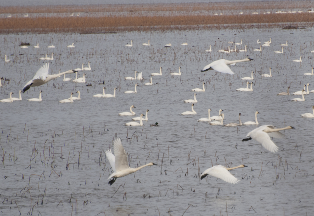
As the Mississippi River leaves Lake Itasca—exiting to the north— it fishhooks through northern Minnesota, passing through large and moody lakes, gradually widening into a respectable stream. Lakes Bemidji, Cass, and Winnibigoshish (“miserable dirty water lake” in the Ojibwe Indian language) are but three of the thousands of lakes created by when the glaciers retreated, which gave us all those places to build summer homes.
 This land is the ancestral home of Dakota and Ojibwe Indians. The Dakota moved further south and west beginning in the 17th century. The Ojibwe—migrating west after conflict with Europeans and other Native Americans—moved into the area around the time the Dakota were moving south. In the marshes, wild rice (not actually rice but the seed of an aquatic grass plant) is abundant; it has been a dietary staple for centuries and still is today.
Most of the early European settlers were Scandinavians, folks who knew how to survive and thrive in the harsh northern climate. They came for jobs in logging and mining and built towns like Bemidji, Grand Rapids, Little Falls, Brainerd, and St. Cloud. For people who choose to live in the Headwaters region, winter isn’t just a season—it’s a lifestyle. Folks get outside regularly during the long and often brutal winter for cross-country skiing, broomball, and ice fishing; snowmobiles aren’t just recreational vehicles but another way to get to the local pub.
As the river reaches the Twin Cities of Minneapolis and St. Paul, it descends a quick 65 feet through St. Anthony Falls, then flows through a narrow gorge. The Twin Cites developed at the northernmost navigable stretch of the river. Three million people come together to create one of the most vibrant metropolitan areas in the US with a diverse art scene, high tech businesses, progressive politics, and a lively food scene.
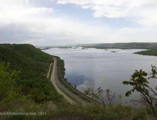
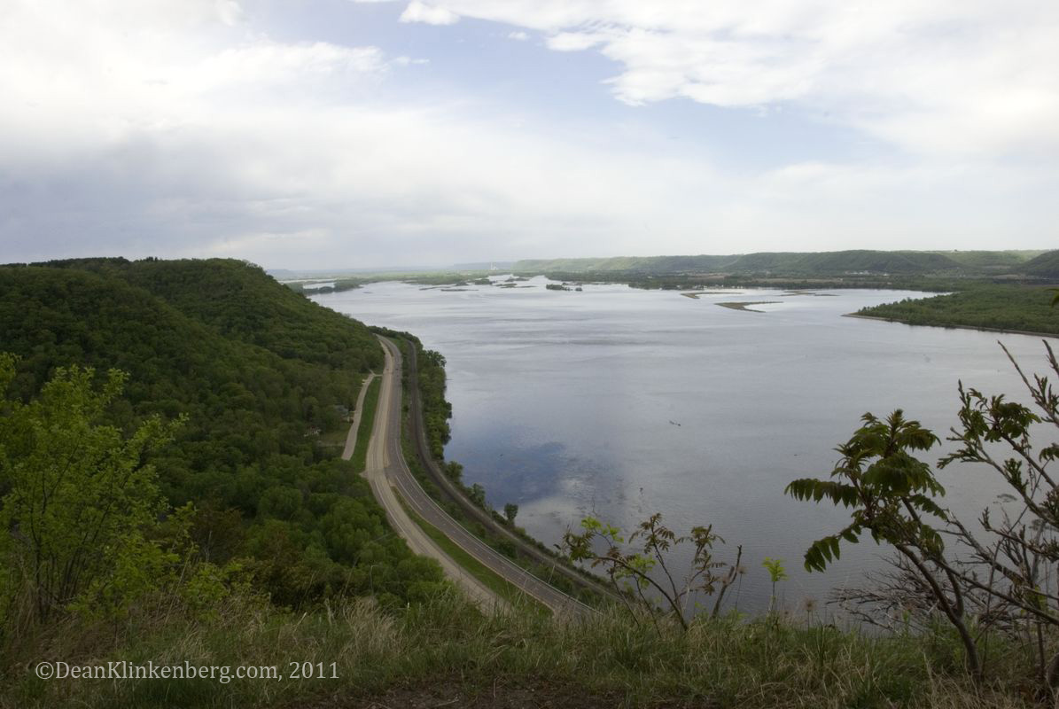
 South of the Twin Cities, the Mississippi settles into a scenic valley some five miles wide flanked by the yellow facades of limestone bluffs that rise 500 feet above the river. Early explorers, unaware of the prairies that extended out from the blufftops, mistook them for mountains. Through the blufflands, small and medium-sized towns like La Crosse and Dubuque hug the river, sometimes terracing up into the coulees (valleys).
The river, barricaded (but not tamed) by a series of dams built to raise water levels for big commercial boats, lulls its way through the valley except when the annual rise brought by melting snow and spring rains renders the dams irrelevant, if only for a few weeks. Canoes and fishing boats navigate the same channel as 15-barge tows that stretch four football fields long.
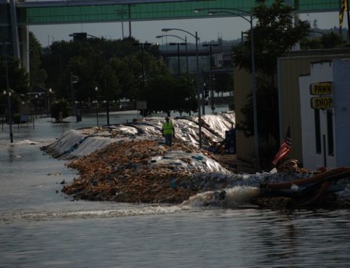
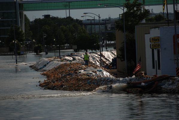
At the Quad Cities, the river takes a sharp turn to the east, a course it will follow for the next 40 miles, confusing anyone who uses the river as a reference point for driving around. (To get to Iowa from Illinois I have to go north?) The Rock Island Rapids spurred settlement of Davenport, Rock Island, and Moline, as boats passing through had to take on special pilots to navigate the tricky waters. Today, those rapids are buried under deep water created by dams. The Quad Cities region is a pleasant and friendly place to pass the time—big enough to have a lot going on but small enough to be free of some of the less desirable aspects of city life, like two-hour commutes.
 The bluffs decrease in height as the river continues south and the wild sections are interrupted more often by industry and rows of corn where wetlands used to be. The river passes by Nauvoo—a small river town laden with a big dose of religious mythology—and Hannibal—a small city that has embraced its role in our cultural mythology.
Near St. Louis, the Missouri River—a slightly bigger and faster river—joins the Mississippi and the two rivers arm-wrestle for 100 miles before their waters fully merge. The Mississippi is an industrial highway through St. Louis, flanked by refineries, power plants, and one of the largest inland ports in the US. St. Louis is a crossroads city that looks East, supplied the West, and is infused with a heavy dose of Southern culture.
After St. Louis, the river is bigger, deeper, and faster. Nearly 100 miles south of St. Louis, the river passes through Thebes Gap, a seven-mile long gorge some 3000 feet wide bracketed by limestone bluffs nearly 400 feet tall. The gorge ends at Commerce, Missouri and the landscape suddenly and dramatically opens up into the Mississippi Embayment. Until five million years ago (just yesterday!), this area was a shallow, northern arm of the Gulf of Mexico. Today, it is a 50-mile wide floodplain through which the Mississippi meanders. The New Madrid fault runs underneath this area and occasionally sends out small tremors to remind folks that it is still around and capable of more, like the 1812 quake that did widespread damage when the region had few cities.
South of the Ohio River, the Mississippi again doubles in volume and enters the broad, flat expanse of the alluvial floodplain in Mississippi and Arkansas known as the Delta. Here, cotton was once king; plantations and segregation ruled the day; and a music born of hardship inspired the world to get up and tell it like it is.
 Memphis, the city nearly wiped out by a devastating yellow fever epidemic in 1878, thrived to give us dry-rubbed ribs and rock-and-roll. In Memphis, you can visit the final resting place of Elvis and enjoy the blues on historic—if touristy—Beale Street.
Where cotton plants once emerged from the rich Delta soil, casinos now rise. Dealers have replaced pickers and Bombay’s gin has replaced Whitney’s. Further downriver, two historic communities of the Old South sit perched on a high bluff: Vicksburg and Natchez. Vicksburg survived a six-week siege during the Civil War. Damaged pride kept the town from celebrating Independence Day until after World War II, because July 4th was the day the town surrendered to the Union Army. Natchez is famed for both the high-brow lifestyle represented by its antebellum mansions and for the low-brow entertainment once found under the hill.
As the Mississippi enters the steamy swamps and bayous of Louisiana, old plantations dot the landscape and descendants of Acadian immigrants blend into the landscape. Some founded communities in places like Lafayette or in Pointe Coupee Parish; others were happy to make a go of it in the swamp. Food is central to the quality of life and sense of identity; ask a hundred people for their gumbo recipe and collect a hundred variations.
At Baton Rouge, commerce is king. From the top floor of the 34-story Art Deco state capitol, you can see a river lined with refineries and filled with giant ocean-going vessels. The Mississippi from here to New Orleans has been given the unflattering nickname of “Cancer Alley” because some believe its residents have unusually high rates of cancer, presumably caused by industrial pollution.
The last major city along the Mississippi River, or the first if you are coming from the Gulf, is a cultural bouillabaisse, as it has been so since its founding. Residents of New Orleans have lived under the flags of France, Spain, the US, and the Confederacy. The city’s role as a major port attracted a diverse population: Germans and other northern Europeans, African slaves, Native Americans, Creoles, Cajuns, Italians, Spanish, free blacks from the Caribbean. Slaves, free blacks, and whites mingled much more closely than in other parts of the south, although their interactions weren’t necessarily cordial.
 The city has (mostly) recovered from Hurricane Katrina, the disaster that killed nearly 2000 people and caused over $80 billion in damages along the Gulf Coast. Even though many folks have moved back to the city, tens of thousands of people who fled New Orleans have not returned. If you stick to the French Quarter and adjacent areas, you may find it hard to believe that the disaster ever happened, but New Orleans today is a smaller city and many of its neighborhoods have changed.
To say New Orleans has a complicated history is to say that Napoleon had a bit of a setback at Waterloo. Maybe the confluence of all these troubles is why the city has given us some of the best food and music anywhere. When life sucks, you return to the basics, the things you control yourself, like what you eat, and you let your music express the sentiments that can’t be spoken aloud.
Below New Orleans, the river fans out into a broad swath of coastal marshes that were built by centuries of silt carried down the river. Deep in the delta, the community on Delacroix Island was populated by Isleños, immigrants from the Canary Islands. In some parts of St. Bernard Parish you can still find folks who sing traditional decimas (traditional Spanish songs usually sung in ten-line stanzas).
The Mississippi River ends its journey at the Gulf of Mexico but carries with it all of the good and bad from upstream. Crops from the fertile plains are transported to ports around the world, while many of the chemicals used to fertilize those plants—nitrogen and phosphorus, in particular—settle into the Gulf of Mexico around the mouth of the Mississippi, creating a dead zone—now estimated to cover over 6,000 square miles of the Gulf—where algae go crazy and devour all the dissolved oxygen so no other organisms can survive.
But let’s not end on a depressing note. In spite of our efforts to force the Mississippi River to bend to our will, it remains one of America’s great places, with a diverse ecosystem and vibrant communities along its banks.
Take a hike along the river. Canoe the backwaters. Eat a slice of pie at a small town café. Have a drink at a local watering hole. Stick around long enough to chat with the folks who live along the Mississippi. You’ll meet some of the friendliest people around, folks who are linked together by a shared passion for the river and all it symbolizes.
In short order, you’ll begin to understand that this great river, even after all our “improvements”, is still a remarkable place.
Community-supported writing
If you like the content at the Mississippi Valley Traveler, please consider showing your support by making a one-time contribution or by subscribing through Patreon. Book sales don’t fully cover my costs, and I don’t have deep corporate pockets bankrolling my work. I’m a freelance writer bringing you stories about life along the Mississippi River. I need your help to keep this going. Every dollar you contribute makes it possible for me to continue sharing stories about America’s Greatest River!
© Dean Klinkenberg, 2011,2018
Thanks! Will do.
Just paddled the 2nd Annual Yellow River Yakfest this last extremely humid weekend and after waking Sunday morning in a bit of a haze my husband and I decided a road trip before heading home was in order. We left our very air conditioned Marquette B&B (no tents this steamy weekend)and crossed over into WI and headed upstream to Lacrosse for lunch then over into MN. and back down the IA side…we crossed back over again when we arrived home in the Quad Cities. We love spending time on, in, around our “Big River” and we love reading about it too. Keep the stories coming Dean!
Thanks, Linda. I’m glad you found the site and are enjoying what I’ve posted so far. Please check back in the coming weeks as I’m about to add new stories about the people and places I’ve encountered. As for your question about the flow of the river, I hate to get in the middle of a marital dispute, but you are right. As the Mississippi passes by Dubuque, it flows south, except for a brief turn to the southwest. I believe the only place where the river flows north for any significant length is right after it exits Lake Itasca in northern Minnesota and flows toward Bemidji; otherwise, there are many places where the river cuts a meandering path where it may turn to the north for a very short stretch. Hope that helps.
Dean
happily by accident found your piece on the Mississippi—–loved it. My husband and I just moved close to the river. My origin search began from a disagreement regarding the directional flow of the river at Dubuque, IA. I really hadn’t given it a lot of thought——he says flows north====i say south—-do you know who is correct ———–guess I’ll have to take a compass next time we’re out. I know in Davenport it is east-west and I know there are small areas where there is some northern flow——just didn’t think Dubuque was one of them. Again great information and for whomever reads it they will want to explore